
The Slick
California Endures Whipsaw Climate Extremes as Federal Support Withers
Data and aid to fight landslides fueled by bigger fires and intense storms are imperiled under Trump
As humans continue burning fossil fuels, global temperatures are rising in startlingly unpredictable ways. The trend is increasing instances of so-called compound dangers, such as landslides hurling millions of tons of mud, boulders and trees down hillsides charred by wildfires.
Such a catastrophic event killed 23 people in California’s Santa Barbara County in 2018, when unusually hard rains pounded the Santa Ynez Mountains for just 30 minutes while the Thomas Fire — among the largest in state history — still smoldered.
Los Angeles was spared from similar devastation after a mass of moisture from the Pacific drenched the county this month — making November among the wettest on record.
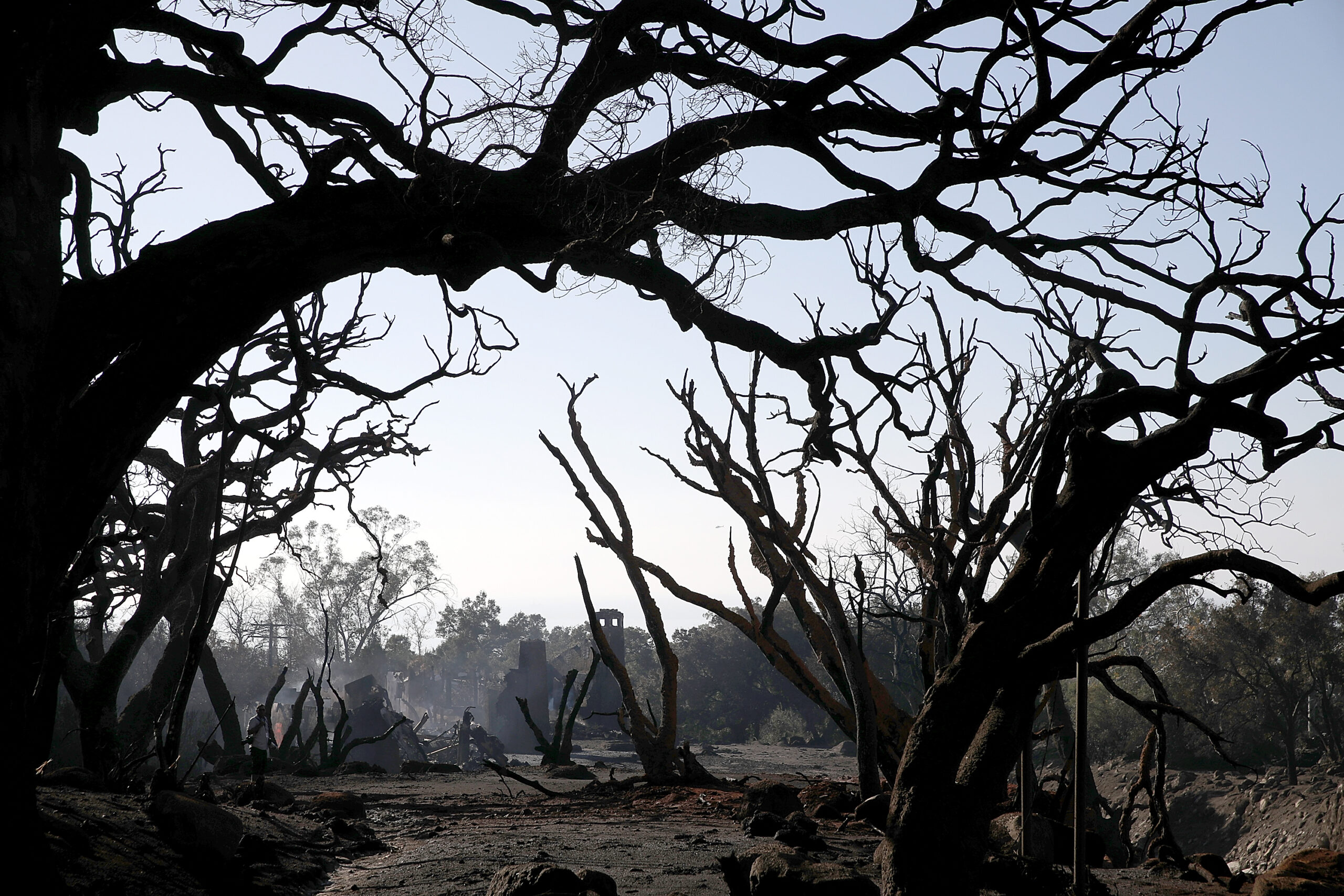
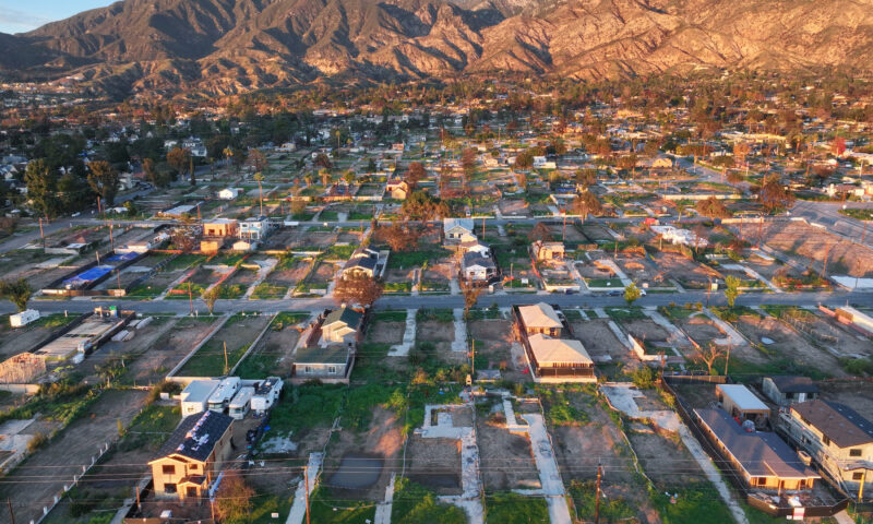
The county recorded no major property damage, but evacuation warnings before the storms were a reminder of how dangerous debris flows can be following major fires. Those advisories applied not just to communities scarred by the Eaton and Palisades fires, such as Altadena and Malibu, but to those areas that had burned earlier too. Homes and properties that escaped the flames in January will face life-threatening landslide hazards for years.
Since 2021, the U.S. government has recognized risks from landslides and created an advisory committee to address such threats. But as scientists draw clearer links between climate extremes, and sound the alarm over rising greenhouse gas emissions, the government under President Donald Trump is increasingly unable and often unwilling to help residents prepare for and survive such events. The state is stepping in to fill the void, but lacks funding and resources that proved crucial in the past.
The California Geological Service deploys Watershed Emergency Response Teams following some fires to assess threats to life and property. They use satellite data collected by federal agencies, whose debris flow hazard websites were not updated during the 43-day federal government shutdown and could be imperiled in future funding lapses.
Local emergency planners use those surveys to understand where mudslides might occur to prepare personnel for deployment.
“I rely on this as an easily accessible resource, and there’s nobody I can talk to [at the U.S. Geological Service] right now,” Kelly Hubbard, the director of the Office of Emergency Management in Santa Barbara County, said before the shutdown ended Nov. 13.
Eric Huff, the deputy director of resource management at CalFire, said that California is able to find “workarounds” to prepare for debris flows.
“It wouldn’t be the same as modeling products from [the U.S. Geological Survey], but we have the capability and first-hand experience to do it now,” Huff said.
While President Trump has dismissed climate change as a “con job,” scientists have grown more confident that global warming is supercharging climate events that amplify the volume and frequency of debris flows.
Research funded by the U.S. Geological Survey concluded that heavy, sudden rainfall due to climate change could result in major landslides about once a decade in Southern California. Past atmospheric rivers, like the one that soaked Los Angeles in November, have unleashed heavier rains because of climate change. A study in the Proceedings of the National Academy of Sciences attributed “nearly all” increases in the size of California wildfire burn areas since the 1970s to hotter and drier weather.
The devastation from landslides accelerated by climate change could be enormous. In another paper, researchers used projected rainfall increases to map out the theoretical impact of the Thomas Fire were it to happen in 2050 and 2075, factoring in that the fire would be larger.
They found that compared with 931 “high hazard” basins in 2017, there would be 2,385 areas in Santa Barbara and Ventura counties at risk of debris flows by 2075.
Aid Request Ignored
As the federal government reopens, Los Angeles County could feel impacts from Congress’ failure to fulfill California’s estimated request for more than $1 billion in supplemental aid from the Federal Emergency Management Agency’s Hazard Mitigation program.
The request for $34.2 billion in total aid from various FEMA and Small Business Administration accounts, among others, was submitted (initially for close to $40 billion) by Gov. Gavin Newsom to House Speaker Mike Johnson and other congressional leaders after the fires.
The budget bill that reopened the federal government does not include this money. Even if it did, President Trump has threatened to withhold aid from California.
The hazard funds are intended “to protect communities from the compounding impacts of extreme weather,” including drainage improvements in fire-scarred areas, said Claire Berry, a spokesperson for Rep. Judy Chu, whose district includes Altadena.
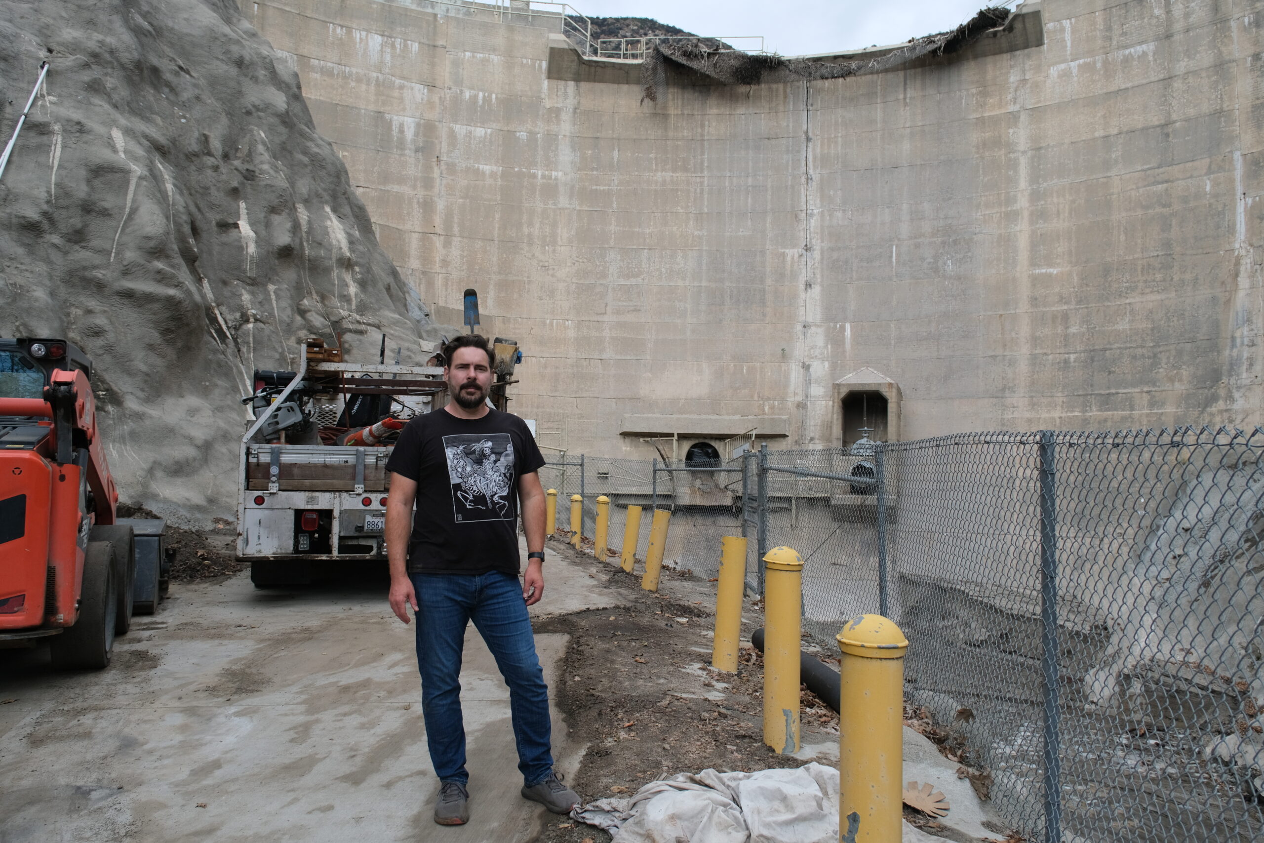
Zak Clark, director of operations at Nature Friends, stands in front of Sierra Madre Dam, which incurred minor damage from a debris flow in February. Photo by Aaron Cantú.
Some $13.5 million in FEMA money helped Santa Barbara County rebuild and enlarge the Randall Road Debris Basin after fatal mudslides along San Ysidro Creek, the Montecito Journal reported. The catch basin can now contain 97,000 cubic yards of mud and debris, about as much as a long-range oil tanker could hold.
During a February rainstorm in Los Angeles County’s Sierra Madre Canyon, where buildings burned in the Eaton Fire, a 69-foot concrete debris dam was briefly overwhelmed. The Sierra Madre Dam, built almost a century ago and maintained by the county, had not overflowed since 1969.
In mid-October, the handrail along the dam’s crest was still torn open from the spill more than eight months before. Eclectic single family homes practically built into the trees and rock lined the road leading down from the dam.
Zak Clark, director of operations for the local nonprofit organization Nature Friends, recalled “a constant stream of trucks” in the months after the storm to remove debris behind the dam wall.
He lives in the nonprofit’s remaining building on a slope in Little Santa Anita Canyon — the other one, a clubhouse built 100 years ago in folk German architectural style, was destroyed in the fire.
The damaged facade has started hosting gatherings again, and volunteers planted California-native plants — buckwheat, seaside daisies and willowherb — after removing powdery, burned soil from the lodging’s grounds. But the surviving building is not insured because it is too expensive, said Clark, a native of disaster-prone Appalachia.
He is frustrated at what he sees as a refusal to acknowledge worsening fires and storms and a lack of political will to protect homes.
“It’s like getting punched in the face over and over again and thinking it won’t happen again,” Clark said, pointing to the last five years of wildfires in the state as evidence. “We have to learn we’re getting punched.”
Nature Friends’ property is bisected by a descending mud path with short rail-and-timber dams to stop rocks from smashing into houses below. The defense is “likely to be overtopped” with very high risks for homes, the state warned weeks after the Eaton Fire. Mud from this year’s storms now clog the dams.
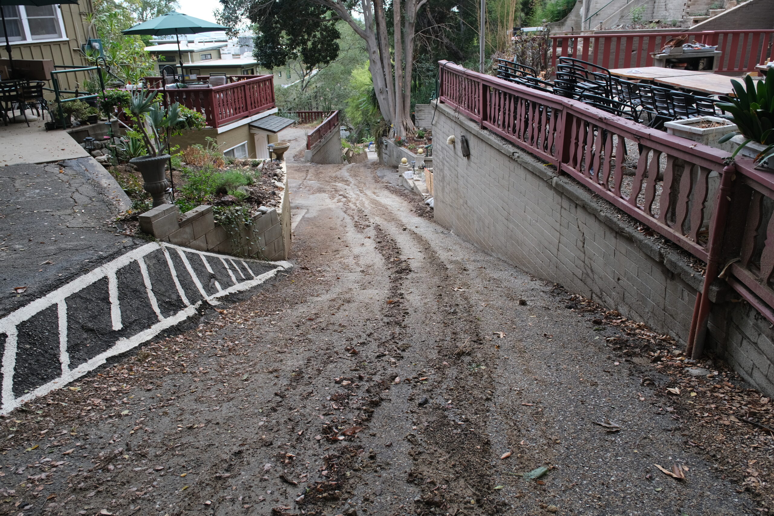
A pathway bisects the Nature Friends’ property in Little Santa Anita Canyon. Two rail-and-timber debris dams block rocks from tumbling toward homes below. Photo by Aaron Cantú.
Aircraft from the California Institute of Technology equipped with 3D imaging technology found that mudflows resulted after the fire incinerated oak trees and chaparral that had kept soil in place. Scorched dirt slid down the mountains and collected along stream channels, loaded to blast down as mud during heavy rain.
But the nearly two dozen drainage basins in the Eaton Fire burn scar were able “to barely hold the material,” said Caltech doctoral candidate Emily Geyman on a podcast from July. It even helped clear away some fire debris from the mountains, like a hearty sneeze.
Although precipitation was heavy during November’s storms, it fell steadily in the course of several days — sparing the area the far worse effects of extreme rain bursts.
Before the rain, Sierra Madre police visited homes and advised residents to evacuate. But Clark chose to stay. So did his neighbors, who called each other to gauge whether to leave. The debris dams were filled with mud, but they held.
Los Angeles County’s total debris storage from the coast up through the Antelope Valley is 9 million cubic yards, slightly more than the amount of earth removed to build Dodger Stadium. But in the face of worsening climate change, the costs of maintaining these basins could become untenable, said Joe Wartman, an engineering professor at the University of Washington.
The structures have “served those areas well and protected a lot of people from the inundation of these debris flows,” Wartman said, but “how well are they sized for the new climate?” That will be measured in money, destruction and pain.
Copyright Capital & Main 2025


-

 Column - State of InequalityMay 21, 2026
In California Governor’s Race, Xavier Becerra Walks Away From Single-Payer
-

 Latest NewsApril 28, 2026
A May Day Push to ‘Shut It Down’ Takes Shape Across the Country
-
 The SlickApril 29, 2026
With Promises of Money, Controversial Gas Pipeline on Navajo Nation Passes First Hurdle
-
 Deadly Dust: The Silicosis EpidemicMay 6, 2026
California Could Be the First State to Ban Quartz Countertops
-

 Latest NewsApril 27, 2026
As the U.S. Spends Billions Fighting Iran, War-Driven Inflation Hits Working Families Hard
-

 Latest NewsMay 1, 2026
In One of L.A.’s Food Deserts, ‘Hands That Harmed Are Now Hands That Heal’
-

 Column - State of InequalityApril 30, 2026
Don’t Call It Upward Mobility If People Still Can’t Afford to Live
-
 Latest NewsMay 5, 2026
Fire Recovery Could Wipe Out Altadena’s Affordable Rentals